
Kumara Parvatha Trek
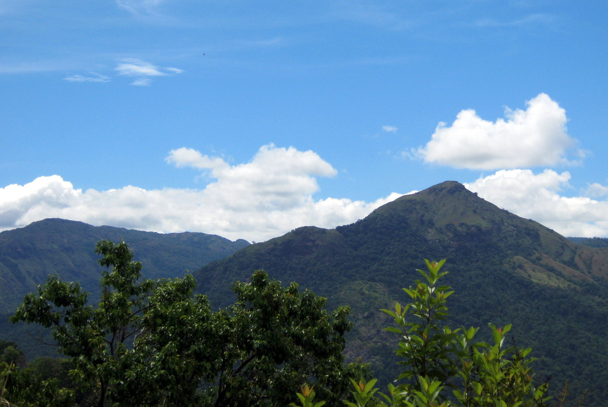
Kumara Parvatha, also called Pushpagiri, is one of the most exciting trek destinations in Karnataka.
Kumara Parvatha also called Pushpagiri, is one of the exciting trek locations in Karnataka.
Popular among the trekking fans as KP, the Kumara Parvatha Trek trail is well trodden but equally challenging , typically takes an overnight stay at the mountains to complete.
Popular among trekking enthusiasts as KP, the trail is well-trodden yet equally challenging, typically requiring an overnight stay in the mountains to complete.
B
efore diving into the trails, let’s get oriented and understand how to choose your route.The trek follows an east–west orientation across the Western Ghats, scaling the third-highest peak in Karnataka. The eastern end starts at Beedehalli, a tiny village about 22 km from Somwarpet in Coorg. The western end is right at the car street of Kukke Subrahmanya Temple.
Between these points lies varied terrain with equally varied difficulty. Approximately at the midpoint is the Kumara Parvatha peak, rising over 5,600 feet above sea level.
Your first decision: start from the Subrahmanya side or the Beedehalli side?
Next, decide whether to do the full trail or just go up to the KP peak and return. Either way, it's about 20 km of trekking.
Let’s look at the pros and cons of both ends to help you decide.
Why Start from Kukke Subrahmanya?
Kukke Subrahmanya has better connectivity and facilities—hotels, restaurants, shops—and of course, the Kukke Subrahmanya Temple.
It’s easily accessible from major cities. See how to reach from Mangalore and Bangalore—the two primary options from west and east respectively. There are daily buses from both cities. Kukke Subrahmanya also has a nearby railway station, though train frequency is limited.
The bus stand is just 2 km from the forest edge where the trek begins. Lodges, restaurants, shops, and the temple (which offers a free wholesome meal) are close by.
In short, Kukke is well-equipped whether you're starting or ending your trek.
What About Beedehalli?
Beedehalli is connected to Somwarpet by a single 22 km bus service. For longer connections—like Bangalore (240 km, ~6 hours) or Madikeri (40 km, ~1.5 hours)—you must reach Somwarpet. There are about 6 direct buses from Somwarpet to Bangalore (1 Rajahamsa and 5 Sarige) and several to Madikeri.
If that one bus to Beedehalli doesn’t fit your plan, hire a local jeep to Somwarpet, a common travel method in the region.
Check out 4 Route Ideas: Bangalore to Kumara Parvatha to create your travel plan.
In summary: Kukke is better connected.
Which Direction is Better: Kukke or Beedehalli?
Beedehalli has the edge. Here’s why:
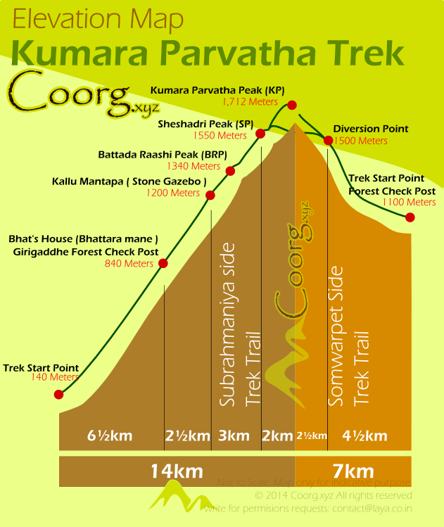
The 14 km trail from Kukke involves a climb of about 1,500 meters. From Beedehalli, it’s a 7 km climb with 600 meters elevation gain. Beedehalli sits at 1,100 meters, Kukke at about 140 meters.
So, Beedehalli is less challenging.
Another factor is the trail type:
* From Beedehalli, the path passes mostly through thick forest, shielding you from the sun—especially helpful during hot days.
* From Subrahmanya, the first 6.5 km is through steep, forested terrain. Then comes open grassland with a steep gradient, little shade, and strong headwinds. Only the last 2 km offers forest canopy again.
That makes the Beedehalli trail easier and more comfortable.
Check out 4 Route Ideas: Bangalore to Kumara Parvatha for more planning help.
All it takes is a weekend for that much-postponed KP trek. Easier than you think. More rewarding than you imagine!
What to Carry to KP
Essentials:
* Backpack
* Sleeping Bag/Mat
* Camping Tent
* Clothes
* Towel
* Toilet Paper
* Toothbrush & Toothpaste
* Whistle
* Water bottles
* Food
* Windcheater/Jacket
* Torch (prefer LED, lightweight, waterproof)
* Garbage bag (doubles as waterproof packing)
* Cap (wide-brimmed hats are better than baseball caps)
* Sunglasses
* Medicine
Camera:
SLRs are great but heavy (~1 kg). Prefer a wide-angle lens. Skip zooms, tripods, or bulky bags. Use a waterproof polybag. Fully charge the battery and leave the charger behind.
Compact cameras are ideal—lightweight and easy.
Mobile Phone:
Signal is strong at Kukke and Beedehalli, but unreliable in between. Prefer basic phones with long battery life. Turn off your phone when there’s no signal to save battery. Text instead of calling.
See the elevation difference between base points. The Somwarpet side starts at ~1100 m, making the climb shorter and less strenuous—7 km vs. 14 km from Kukke.
Plan Your Trek
Just a weekend. Easier than you thought. More rewarding than you imagine!
Beginner Tips:
Check with climbing/trekking clubs in your city. If you’re from Bangalore, check out the Bangalore Mountaineering Club—they organize regular KP treks.
Equipment Rental: Rent Sleeping Bags and Tents from
* [www.rentongo.com](http://www.rentongo.com)
* [www.shadytents.in](http://www.shadytents.in)
* [www.bmcindia.org](http://www.bmcindia.org)
* [www.ozoneindia.com](http://www.ozoneindia.com)
Luggage Storage at Kukke Subrahmanya Temple: A free baggage room (open shelves, not lockers) is available next to the temple tower. Don’t leave valuables.
Kumara Parvatha
The 14 km trail from Kukke involves a steep 1,500 m climb, starting at just 140 m elevation. In contrast, Beedehalli starts at 1,100 m and reaches the peak with a gentler 600 m ascent over 7 km—making it the easier option overall.

How to reach Kumara Parvatha Trek base from Bangalore. Trek Itinerary via Somwarpet
Kumara Parvatha Trek Itinerary via Somwarpet
Kumara Parvatha
Kumara Parvatha Trek Elevation Map
The 14 km trail from Kukke involves a steep 1,500 m climb, starting at just 140 m elevation. In contrast, Beedehalli starts at 1,100 m and reaches the peak with a gentler 600 m ascent over 7 km—making it the easier option overall.
How to reach Kumara Parvatha Trek base from Bangalore. Trek Itinerary via Somwarpet
Bangalore to Kumara Parvatha itinerary-1
Kumara Parvatha Trek Itinerary via Somwarpet