
Bangalore to Coorg via Mysore
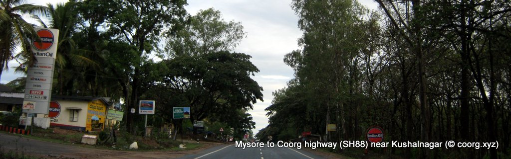
Myosre to Coorg road near Kushalnagar
Take diversion at Kushalnagar for Somwarpet and Bylakuppe
T
he road distance from Bangalore to Madikeri via Mysore is about 250km (155 miles). The driving conditions are mixed, but by and large it is a smooth ride. The road condition is pretty good on the main highway (SH17 & SH88), baring a few stretches towards Madikeri and the diversions to other destinations in Coorg, off SH88.You'll be driving on two well maintained state highways - SH17 and SH88 - that connect Bangalore with Coorg via Mysore. From Bangalore to Mysore ( distance about 140 km ) you would be using the SH 17 and from Myosre onward to Madikeri it is the SH 88.
The Bangalore to Mysore route is like this (SH17) : Bangalore - Bidadi - Ramanagaram - Chennapatna - Maddur - Mandya - Srirangapatna - Mysore. The distance is about 140 km.
The second lap is (SH88) : Mysore - Yelwal - Hunsur - Kempalapura - Piriyapatna - Bylakuppe - Kushalnagara - Suntikoppa - Madikeri . This stretch’s distance is approximately 115km.
If it is not part of your itinerary, you can bypass Mysore city.
There are two ways to bypass Mysore city. The first option is by taking the bypass road after Srirangapatna (about 15km before Mysore city) and the second bypass option is to take the Mysore ring road (about 10km before Mysore city).
If you take the bypass route near Srirangapatna , you can easily save some 30-45 minutes of Mysore city traffic. At Srirangapatna you will cross two major bridges across Kaveri River.
You enter Srirangapatna island through the first bridge and exit through the second bridge. Soon after you’ve crossed the second bridge out of Srirangapatna, you encounter a large junction. Take the right turn and soon you’ll see a railway gate. You need to take the road that crosses the railway track. The road at this point make a tentative left turn.
Unlike the Bangalore-Mysore road ( SH 17 ) you have been on so far, this particular road is narrower and much less crowded. This road zigzags through some wide stretches of paddy and sugarcane fields. After about 20 kilometers , at a place called Yelwal ( or Eliavala ) this bypass route joins a main highway, the Mysore-Mangalore SH88.
Before that you would have crossed the Ranganathittu bird sanctuary and the Brindavan Gardens ( KRS Dam) on your right. Both of them are a bit off from your road. A short detour towards right is needed to reach these two places.
As mentioned earlier, the second option to skip Mysore city is the take the Outer Ring Road, that encircles Mysore city. The Ring Road crosses SH 17 ( Bangalore-Mysore Road) at a major junction some 10km ahead of Mysore city. Take the right branch at this junction. About 15-20 minutes drive later , the ring road crosses the Hunsur road ( SH 88). You need to take the right turn into the Hunsur road. Though ring road is less crowded than the road that crosses right through Mysore city, it is a bit longer.
So if it is not the peak hours, you can easily drive through the city. The Bangalore-Mysore road eventually takes you to the Mysore Bus stand or railway station area . A little after the railway station turn right into the Hunsur Road (SH88). This road takes you out of the city towards Madikeri direction.
The second lap of the route to Madikeri is like this : Mysore - Yelwal - Hunsur - Kempalapura - Piriyapatna - Bylakuppe - Kushalnagara - Suntikoppa - Madikeri . This stretch’s distance is approximately 115km ( 72 miles ).
Baring the final 20 or 30 km stretch just before Madikeri , the SH88 is in excellent condition. For some considerable distances, it is 4 lane otherwise it is 2 lane. Also unlike the Bangalore - Mysore stretch ( SH17) of the route, the Mysore - Madikeri stretch doesn’t have a lot of fanfare in terms of fancy eateries and stuffs like that. However there are some reasonable restaurants at Hunsur town and also in Kushalnagara. You'll find a couple of Cafe Coffee Day outlets near Kushalnagara.
As you reach Hunsur, the highway splits into a Y junction. Take the right fork , and you will be skipping an otherwise crowded Hunsur town. Just as you take this right fork, on your left is a drive-in restaurant that serves good vegetarian food. Also there is a good coffee shop.
After you come out of Hunsur , SH 88 makes a tentative right turn. The straight road ( SH 88A) leads to Gonikoppal and Virajpet. Though this road also goes to Madikeri, stay on with SH 88 as it is shorter and better maintained. After Hunsur, if you are still right on the SH88 without and deviations you should cross Piriyapatna in about 15 minutes ( 20 km) from Hunsur.
After Piriyapatna a huge arch across the road announces the Tibetan settlement ahead in Bylakkuppe. This is one of the largest and oldest settlements of Tibetan settlements in India. As an indication you can see colorful prayer flags flying in the area. The Golden Temple , Namdroling Nyingmapa Monastery and the Sera Monastic University, one of the largest Buddhist universities in the world , is located in Bylakkuppe. It’s a few kilometers detour towards left from the main highway. For Bylakkuppe take the left diversion from a village square called Kuppam.
Nisargadama, an island formed by river Cauvery is located on the left as you come out of Kushalnagar town. This too is a popular tourist destination in Coorg.
Further ahead the highway passes through a forest. From this point onwards traffic slows down thanks to the narrow and often pothole ridden road condition. Also the road makes numerous bends frequently in this hilly area. This condition prevails all the way up to Madikeri town. In fact this is the slowest lap of the route from Bangalore to Coorg. This last 20-30 kilometers can take anything up to and hour to cover.
As you enter Madikeri town you can spot many signboards by the state tourism department showing directions to various attractions in Coorg.
![]()
- Start early from Bangalore, that's the easiest way to avoid rush hours . During peak hours you'll be spending more time awaiting for food to arrive at the popular joints in Bangalore-Mysore stretch, making you journey still slower.
- Skip Mysore City, take the diversion after Srirangapatna or Mysore Ring Road.
- Road Condition from Bangalore to Coorg is fairly decent ( 2014) , baring a few short stretches.
- Checkout the alternative route to Coorg from Bangalore Bangalore to Coorg via Channarayapatna.
- You can see the comparison between the two routes (Bangalore to Coorg by Road) , that is via Mysore (SH17) and via Channarayapatna (NH48). Factors are compared. Select the best route to Coorg.
- Checkout with travel forums like Team BHP, Indiamike.com etc to get the latest update on the road conditions, esp. helpful during post monsoon months when road conditions typically deteriorate.
- 23 Places to Eat on the way to Coorg, a very comprehensive list of restaurants and coffee shops on the way to Coorg from Bangalore. Listed in the order you drive from Bangalore towards Mysore and then to Coorg
- Those of you head to the Bisle Ghat region see the Bangalore to Kukke Subramanya route directions also.
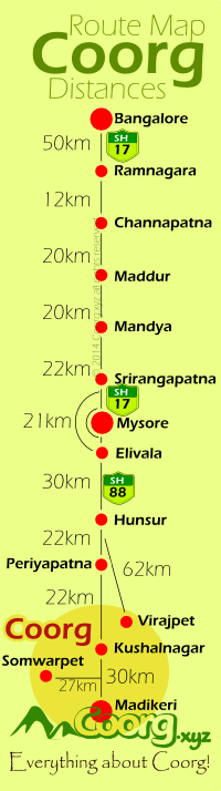
Bangalore to Coorg road map and distances
Bangalore to Coorg by road : Road Map with Distances.
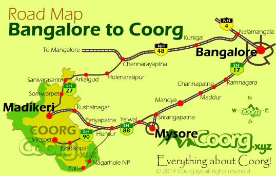
There are two popular routes to drive from Bangalore to Coorg, first via Mysore, second via Channarayapatna
Coorg Route option 1:
Bangalore to Coorg via Mysore :
The Bangalore to Mysore route (SH17) : Bangalore - Bidadi - Ramanagaram - Chennapatna - Maddur - Mandya - Srirangapatna - Mysore.
Mysore to Coorg (SH88) : Mysore - Yelwal - Hunsur - Kempalapura - Piriyapatna - Bylakuppe - Kushalnagara - Suntikoppa - Madikeri .
Coorg Route option 2:
Bangalore to Coorg by NH48 ( distance 291km ) route goes like this: Bangalore City --30km-->Nelamangala--44km-->Kunigal--46km-->Bellur Cross (Nelligere)--45km--> Channarayapatna --22km-->Holenarsipur--22km-->Arkalgud--22km-->Sanivarasante--20km-->Somwarpet--40km-->Madikeri Town
Bangalore to Coorg road map and distances
Bangalore to Coorg
Bangalore to Coorg by road : Road Map with Distances.
There are two popular routes to drive from Bangalore to Coorg, first via Mysore, second via Channarayapatna
Bangalore to Coorg Road Map
Coorg Route option 1: Bangalore to Coorg via Mysore : The Bangalore to Mysore route (SH17) : Bangalore - Bidadi - Ramanagaram - Chennapatna - Maddur - Mandya - Srirangapatna - Mysore. Mysore to Coorg (SH88) : Mysore - Yelwal - Hunsur - Kempalapura - Piriyapatna - Bylakuppe - Kushalnagara - Suntikoppa - Madikeri . Coorg Route option 2: Bangalore to Coorg by NH48 ( distance 291km ) route goes like this: Bangalore City --30km-->Nelamangala--44km-->Kunigal--46km-->Bellur Cross (Nelligere)--45km--> Channarayapatna --22km-->Holenarsipur--22km-->Arkalgud--22km-->Sanivarasante--20km-->Somwarpet--40km-->Madikeri Town