
Road Routes to Nagarhole
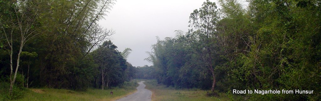
Hunsur to Nagarhole Road
Hunsur to Nagarhole Road
A
series of state highways encircles the Nagarhole forest range, some cross it. The main one being the road connecting Hunsur with Kutta.![]() Hunsur to Kutta Route
Hunsur to Kutta Route
This road passes via the Forest Department Guesthouses ( from where the safari start). So from wherever you are approaching Nagarhole , you need to get to this road to enter the National Park for safari.
Two wheelers are not allowed to drive through Nagarhole. If you are on a bike trip, find out a suitable base to park ( for example the Kutta town, which is only a few kilometers from the Nagarhole safari starting point). and hire a local jeep.
Road from Mysore to Hunsur , that is SH 88 , is excellent . From Hunsur town take the road that passes right through the Nagarhole National Park. This road is located just behind the Hunsur bus station.
If by chance you’ve missed this road, in all probability you are driving towards Gonikoppal or Madikeri, which is a roundabout route to Nagarhole.
Ask for direction to Nagarhole before you’ve crossed the Hunsur bus station ( that appears on your left) and the Nagarhole road is also on your left as you pass the bus station. Just after the bus station is a fuel station. The Nagarhole road passes adjusent to the fuel station.
After about 10 kilometers from Hunsur you’ll reach a village called Nallurpala. The road splits here. Take the right branch to Nagarhole National Park. The left branch goes towards HD Kote. From Nallurpala drive another 10 kilometers , you would reach the Forest Department gate across your road. The gate is always closed and attended by a guard.
There is a register with the guard. You’ve to write down some details ( Vehicle number, no. of people traveling, from, to, your name etc and sign). It’s a two minutes formality, if there is no queue. Usually there is no queue. Then he opens the gate. No fees to be paid. Note, beyond this point no two wheelers are allowed.
Vehicle traffic is allowed only from 6 AM to 6 PM , as the night traffic is not safe ( for you as well as the wild animals ! )
Just before this gate on your right are two the private resorts called Jungle Inn and The King’s Sanctuary. You’ll find Jungle Inn first and The King’s Sanctuary immediately after that on the same (left) side. Both The King’s Sanctuary and Jungle Inn are upscale resorts for people interested in wildlife holidays.
From the forest department gate, Nagarhole Safari Point proper is 28 kilometers drive. You are now already into the forest. Though there are not too many deviations, frequent signposts assures you of direction to Nagarhole.
A few minutes from the above gate , you’ll see another gate ( that is usually kept open) across your road. There is a tribal settlement as well as the an elephant camp at this point. The place is called Murkal and hence the camp as Murkal elephant training camp.
You can spot many elephants of the camp and the mahouts going about their daily routines. On your right is a huge cage made of logs , that is used to lockup the captured (?) elephant. Beyond that is a large water hole. Murkal has the forest department’s guest houses. You can even spot some jungle trails radiating out of the main road.
Ahead you proceed on the main road. A signboard on your left ( if it is still not pulled out by some wild elephant !) says Karmad 6 kilometers.The road to Karmad starts on your right. This goes via a settlement and a less used exit out of the National Park. There is a forest check post as the road crosses the national park border. That’s just for information as theses are the easy landmarks in the forest. You are not going to turn right here. Drive straight for Nagarhole.
You can easily know that you have finally arrived at the base camp in Nagarhole. There are huge bungalows and other buildings by forest department in this area. Somewhere on your left is the place where you can park and from where safari ( by the department’s van) starts.
Beyond the Nagarhole Safari point area, you'll exit the park , though its southern gate. A short drive away is Kutta, further is Kerala boarder.
![]() HD Kote to Bavali Route
HD Kote to Bavali Route
Select this route if you are traveling to Kabini Reservoir area of Nagarhole.
![]()
- No fees to be paid to cross the Nagarhole forest.
- Night Traffic is not allowed. If you've to travel between Hunsur and Kutta after the gate is closed, try the Gonikopal route around the northern periphery of the park. It's a round about though.
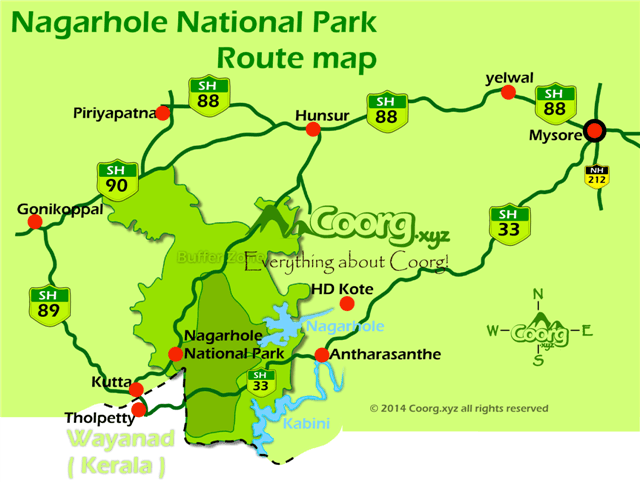
Nagarhole Route Map
Kutta is the entry point to the Nagarhole National Park, especially for those coming from Kerala side. Location wise Kutta is a few kilometers from the Kerala-Karnataka border and the road that connects Kerala and Karnataka pass via Kutta. This road also pass through another wildlife sanctuary – Tholpetty – shortly after crossing into in to Kerala.